In the summer (hiking season) the weather can change quickly, so bring both sunscreen and insect repellent.
Polar bears are not usually seen this far south, but be very careful when crossing rivers. Loosen the hip belt on your backpack and remove one shoulder in case you need to drop it quickly. Use walking poles to cross; wearing a pair of Crocs or water shoes can help.
ARCTIC CIRCLE TRAIL
Ultimate hiking tour in Greenland
-

INLAND ICE TO KANGERLUSSUAQ
From Ice Sheet37 km.From Russel25 km.TypeGravel 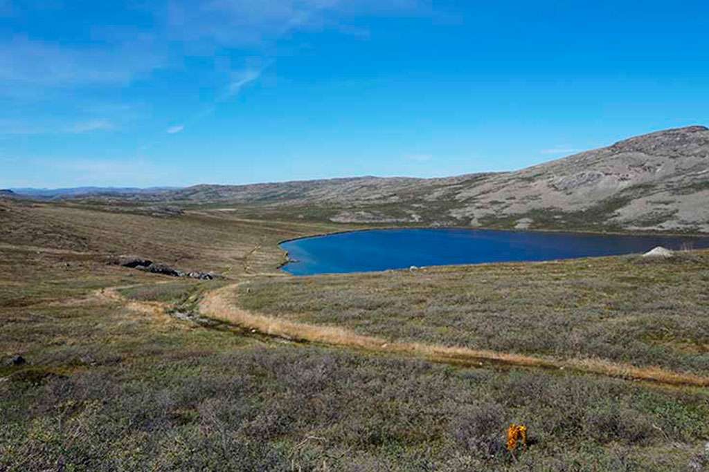
KANGERLUSSUAQ TO HUNDESØ
Length25 km.Climbing425 m.Decline328 m.
HUNDESØ TO KATIFFIK
Length20 Km.Climbing238 m.Decline310 m.
KATIFFIK TO CANOECENTER
Length20 Km.Climbing350 m.Decline350 m.
CANOECENTER TO IKKATTOOQ
Length22 Km.Climbing454 m.Decline224 m.
IKKATTOOQ To EQALUGAARNIARFIK
Length11 Km.Climbing208 m.Decline383 m.
EQALUGAARNIARFIK TO INNAJUATTOQ
Length19 Km.Climbing437 m.Decline303 m.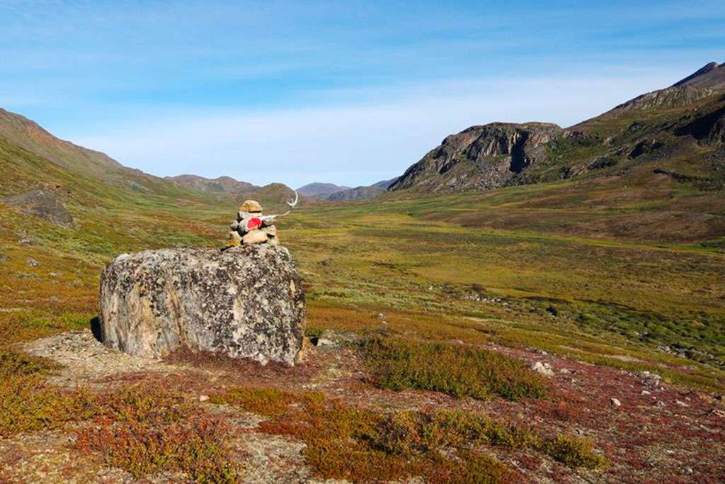
INNAJUATTOQ TO NERUMAQ
Length16 Km.Climbing329 m.Decline440 m.
NERUMAQ TO KANGERLUARSUK
Length17 Km.Climbing226 m.Decline262 m.
KANGERLUARSUK TULLEQ TO SISIMIUT
Length20 Km.Climbing589 m.Decline702 m.
Useful information
 |
![]() Winter - The route is only accessible to snowmobiles or ski tourists. Short days, very cold, but the northern lights are visible.
Winter - The route is only accessible to snowmobiles or ski tourists. Short days, very cold, but the northern lights are visible.
![]() Hiking Season - The midnight sun means long walking days, but temperatures can fluctuate and flies and mosquitoes can be a problem during the day.
Hiking Season - The midnight sun means long walking days, but temperatures can fluctuate and flies and mosquitoes can be a problem during the day.
![]() Shoulder Month - A good time to avoid the majority of walkers and the biting bugs. But it can be cold at night.
Shoulder Month - A good time to avoid the majority of walkers and the biting bugs. But it can be cold at night.
The website is privately owned and is not publicly funded.
Facebook page: https://www.facebook.com/ArcticCircleTrail.dk
-
Health and safety
-
Get there
To fly to Greenland, you must either via Denmark or Iceland. Be warned that flights in and out of Sisimiut may be canceled and delayed if the weather is bad. Flights to and from Kangerlussuaq are more reliable.
-
Get around
There are no roads from Sisimiut or Kangerlussuaq, so there is no point in renting a car. Supermarkets and museums within walking distance.
For the ice cap in Kangerlussuaq, it is recommended to go on an organized tour as it is on a gravel road and special vehicles are required. -
Hike the route
The Arctic Circle Trail takes eight to ten days to hike. It is beautiful, but wild and remote. There are red semi-circle markers on cairns to help guide you, but you should bring a map as confusion is possible in places, especially in bad weather.
Be sure to tell someone in charge when you expect to arrive in Sisimiut or Kangerlussuaq so they can raise the alarm if you don't show up - you might consider renting a satellite phone as extra security or an emergency locator. It is also recommended that you write in the books in the cabins so that there is a dated record of your whereabouts.
Be prepared that if the weather changes it may be a good idea to wait for better weather in one of the cabins, so always bring more food than you need and include a few extra rest days in your plan. -
Sleepover
In Kangerlussuaq, Hotel Kangerlussuaq, located on the 1st floor of the terminal, is an easy choice. There is also Polar Logde, Old Camp and Vandrehjemmet. Camping is also a cheap option.
All cabins (not privately owned) on the route are free to use, but you must be self-sufficient and take a tent if there is no room. Some have toilets; others don't, so you'll have to dig a hole and follow the 'Leave No Trace' rules.
In Sisimiut near the harbor there is the Sailor's Home, which also has a cafeteria on site for dinner and breakfast. In addition to that, you have Hotel Sisimiut and the Hostel. -
Food and beverage
Limited - and expensive - supplies can be bought in Kangerlussuaq, so bring your own camping meals and snacks. For camping stove fuel, don't assume you can find what you want. All food is flown in, so expect frozen meals reheated, hot dogs and some fish.
-
May and June
The month of May will certainly have snow on part of the route. June can have snow on the route close to Sisimiut. Therefore, it can be a wet pastime to go hiking in these months.
-
Midnight Sun
There is midnight sun in summer (from the beginning of June to mid-July), and in winter it is dark almost 24 hours a day. However, not decidedly dark time, when the sun does not reach the horizon, as further north in Greenland.
-
Communication
There is no mobile coverage during the trip. Therefore, we would not advise anyone to go on the trip without a satellite phone or at least an emergency transmitter of some kind.
-
Charging mobile, gps and other
It is possible to charge mobile phones, satellite phones or GPS in the canoe center cabin. It is general. socket (Schuko plug), and not usb.


Population: 56.562 (1.1.2022)
Population density: 0.026/km2
 Northern Light
Natural landscape from another world. The northern lights can be seen all year round in a dark, clear night sky, and they are most beautiful in autumn and winter. In the summer, they disappear into the bright night. Greenland is the main location for this world-class performancebr>
Video: Visit Greenland.
Natural landscape from another world
 Ice and Snow
Experience the ice cap in all its power. Get up close to a strange land of icebergs that float majestically and take on a life of their own. You will see ice everywhere - from the deck of a ship, a helicopter, a dog sled or on a hike. Watch the colors change before your eyes with the reflection of the sun and enjoy the sight of icebergs.
Video: Visit Greenland.
Get up close to a strange kingdom of ice and snow
 The Land of Man
 Throughout the ages, Greenland has attracted people who are not afraid to break new ground and seize opportunities - pioneers in their own way. From the Inuit who immigrated thousands of years ago to a huge and unknown country, to the Vikings in South Greenland, to the many explorers, traders, missionaries, workers and tourists who visited the country.
Video: Visit Greenland.
The Greenlanders call their country the "Land of Men"
ATV Track
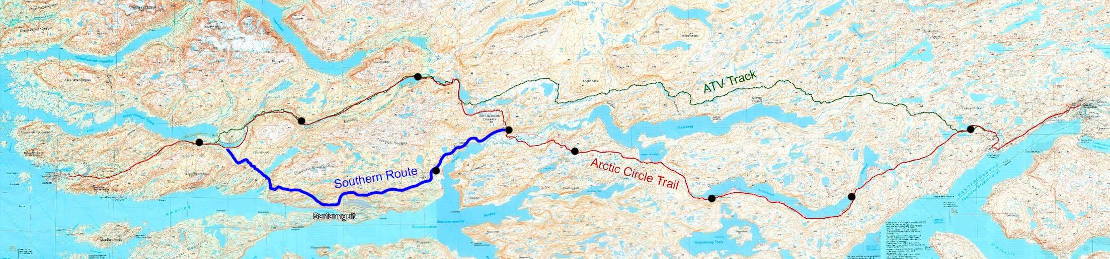
Red route is the normal ACT route. Blue route is the southern route. Green route is the ATV track.
The ATV trail runs north of the ACT for most of the route. If you want to hike most of the route outside the ATV track, you can take the southern route from the Eqalugaarniarfik hut.